


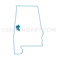
Montgomery Rec. Center, Greene County, Alabama
About
Outline

Summary
| Unique Area Identifier | 521858 |
| Name | Montgomery Rec. Center |
| County | Greene County |
| State | Alabama |
| Area (square miles) | 39.03 |
| Land Area (square miles) | 38.05 |
| Water Area (square miles) | 0.98 |
| % of Land Area | 97.49 |
| % of Water Area | 2.51 |
| Latitude of the Internal Point | 32.98644920 |
| Longtitude of the Internal Point | -87.79028110 |
Maps


Graphs
Select a template below for downloading or customizing gragh for Montgomery Rec. Center, Greene County, Alabama


Neighbors
Neighoring Voting District (by Name) Neighboring Voting District on the Map
- Fosters-Ralph Fire Dept, Tuscaloosa County, AL
- Frierson-Big Sandy Baptist Church, Tuscaloosa County, AL
- Jena Clubhouse, Greene County, AL
- Lewiston Comm. Center, Greene County, AL
- Moundville City Hall A, Hale County, AL
- South Fork, Greene County, AL
- Stewart, Hale County, AL
- Union City Hall, Greene County, AL
Top 10 Neighboring County Subdivision (by Population) Neighboring County Subdivision on the Map
- Big Sandy-Duncanville CCD, Tuscaloosa County, AL (9,260)
- Eutaw CCD, Greene County, AL (4,410)
- Moundville CCD, Hale County, AL (3,534)
- Fosters CCD, Tuscaloosa County, AL (3,043)
- Mantua-West Greene CCD, Greene County, AL (1,814)
- Stewart-Akron CCD, Hale County, AL (1,582)
Top 10 Neighboring Unified School District (by Population) Neighboring Unified School District on the Map
- Tuscaloosa County School District, AL (105,218)
- Hale County School District, AL (15,760)
- Greene County School District, AL (9,045)
Top 10 Neighboring State Legislative District Lower Chamber (by Population) Neighboring State Legislative District Lower Chamber on the Map
- State House District 62, AL (55,022)
- State House District 72, AL (39,414)
- State House District 71, AL (38,094)
Top 10 Neighboring State Legislative District Upper Chamber (by Population) Neighboring State Legislative District Upper Chamber on the Map
Top 10 Neighboring 111th Congressional District (by Population) Neighboring 111th Congressional District on the Map
Top 10 Neighboring Census Tract (by Population) Neighboring Census Tract on the Map
- Census Tract 107.01, Tuscaloosa County, AL (6,568)
- Census Tract 601, Greene County, AL (4,410)
- Census Tract 400, Hale County, AL (3,534)
- Census Tract 103.03, Tuscaloosa County, AL (3,043)
- Census Tract 600, Greene County, AL (1,814)
- Census Tract 401, Hale County, AL (1,582)
Top 10 Neighboring 5-Digit ZIP Code Tabulation Area (by Population) Neighboring 5-Digit ZIP Code Tabulation Area on the Map
- 35474, AL (6,180)
- 35462, AL (5,061)
- 35463, AL (1,749)
- 35480, AL (1,343)
- 35441, AL (1,060)
- 35469, AL (221)